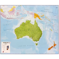
Lovell Johns Australasia flat laminated
Lovell Johns Australasia flat laminated, Political map, Australia, Multicolour, Plasticized cardboard, English, 14 yr(s)
Offres:
*Date of last price update
User Notice: We regularly reference new offers to provide you with the widest selection. However, the displayed results do not reflect all available offers on the market. By default, offers are sorted by price, with the lowest price appearing first.
Similar Products
Product Information
This Australasia political wall map shows the whole continent from Papua New Guinea in the North of the continent down to Tasmania and New Zealand in the south. _x000D_
This political wall map of Australasia features countries marked in different colours, with international borders clearly shown. The map's key shows a panel of flags from each of the countries displayed in this continent map. This political wall map of Australasia also contains population detail, capital cities and all the major towns and cities in this continent.
Product
Weight & dimensions
Width
1200 mm
Depth
1000 mm
Weight
338 g
Features
Map type
Political map
Map coverage
Australia
Designed for children
No
Laminated
Yes
Product colour
Multicolour
Material
Plasticized cardboard
Language version
English
Recommended age (min)
14 yr(s)
NOTE: The above information is provided for your convenience only, and we cannot guarantee its accuracy with the seller.
Customer Reviews
Share your opinion on the product or read reviews from other members.


