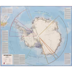
Lovell Johns Antarctica flat laminated
Lovell Johns Antarctica flat laminated, Political map, Blue, White, Plasticized cardboard, English, 14 yr(s), 1200 mm
Offres:
*Date of last price update
User Notice: We regularly reference new offers to provide you with the widest selection. However, the displayed results do not reflect all available offers on the market. By default, offers are sorted by price, with the lowest price appearing first.
Similar Products
Product Information
The Antarctica map includes information from the British Antarctic Survey on scientific research. Information on Antarctica's climate and resources is included and as you would expect with a political map, the territory divisions are shown. Shown also are the major expedition routes, camps and weather stations on Antarctica.The map features hill shading, also contains information on the flora and fauna of Antarctica.
Product
Weight & dimensions
Width
1200 mm
Depth
1000 mm
Weight
340 g
Features
Map type
Political map
Designed for children
No
Laminated
Yes
Product colour
Blue, White
Material
Plasticized cardboard
Language version
English
Recommended age (min)
14 yr(s)
NOTE: The above information is provided for your convenience only, and we cannot guarantee its accuracy with the seller.
Customer Reviews
Share your opinion on the product or read reviews from other members.

